
Indonesia’s National Disaster Management Agency (BNPB) has identified three companies whose concession areas were detected with fire hotspots in Papua Selatan, prompting the authorities to initiate further checks into possible land-clearing activities. The Papua Selatan (South Papua) forest fire investigation is taking place alongside an intensified response involving local authorities, police, residents, and weather-modification operations aimed at reducing the spread of forest and land fires.
BNPB Chief Lieutenant General Kristomei Sianturi announced the identification during a press conference at the Coordinating Ministry for Political and Security Affairs in Jakarta on November 9, 2026. He said the agency had submitted information about the three companies to the Papua Selatan regional government for clarification and field verification.
The announcement followed the agency’s monitoring of hotspots through its digital surveillance application. After examining the locations more closely, BNPB identified areas that appeared to overlap with company concessions and passed the findings to local authorities.
However, Kristomei stressed that the data still required direct inspection. The presence of a satellite-detected hotspot does not, by itself, establish that a company deliberately started a fire or that land clearing was conducted through burning. Investigators must establish the actual conditions and determine whether any prohibited activity took place.
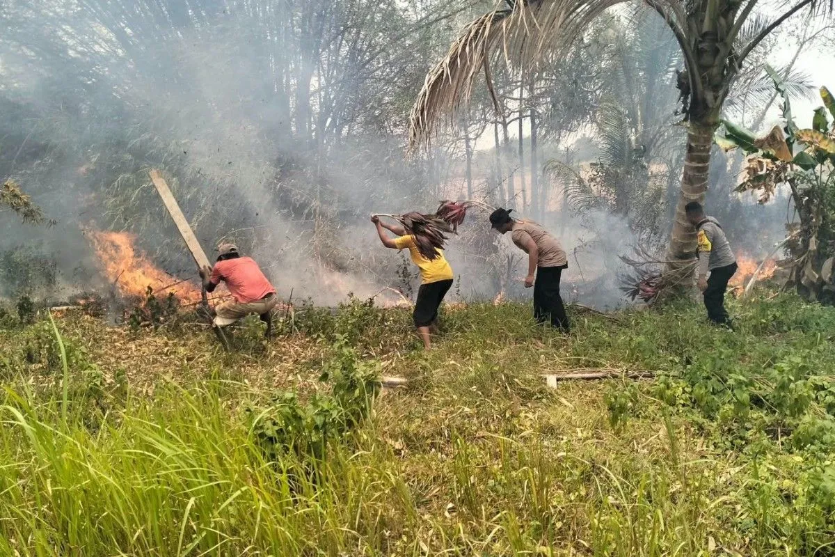
At the same time, the government is strengthening its firefighting response. In Merauke, a joint team involving police officers and local residents successfully extinguished a fire affecting four hectares in Kampung Marga Mulya, Semangga District. BNPB has also deployed two Cessna aircraft to support weather-modification operations in Papua Selatan.
The parallel efforts reflect two priorities: containing active fires and establishing accountability where evidence points to possible violations.
BNPB Identifies Three Companies Through Hotspot Monitoring
The identification process began with the monitoring of fire hotspots through BNPB’s digital surveillance system. According to Kristomei, the agency used its application to track locations where hotspots had appeared and then examined their distribution in greater detail.
The findings indicated that three companies had areas requiring further investigation. BNPB subsequently delivered the relevant data to the Papua Selatan provincial government so that officials could coordinate clarification and verification with the authorities on the ground.
“There are three companies that we have identified and whose data we have submitted to the regional government,” Kristomei said, as quoted by ANTARA on November 9.
He pointed out that the next step was to establish whether burning had occurred as part of land-clearing activities or whether the detected hotspots had another explanation.
“We need to conduct field clarification and check whether burning was carried out as part of land clearing or not,” he said.
Importantly, BNPB did not publicly disclose the names of the three companies during the announcement. The agency said that verification was still required before any conclusions could be drawn.
This distinction matters in environmental investigations. Satellite monitoring is an important tool for identifying possible fire locations, but determining responsibility requires additional evidence, including field inspections, land-use records, and information about activities within the relevant concession areas.
The identification therefore represents an investigative lead rather than a final finding of corporate wrongdoing.
Government Requests Verification Following November 4 Letter
The investigation has developed through coordination between central and regional authorities.
According to ANTARA’s report on November 10, the verification process followed a letter sent by the Minister of Forestry to the Governor of Papua Selatan on November 4, 2026. The letter sought clarification regarding land conditions in areas where satellite monitoring had indicated possible burning.
BNPB Chief Kristomei said the agency had coordinated with the regional government, the Indonesian National Armed Force (TNI), and the National Police (Polri) to arrange direct inspections.
The agency also presented its preliminary findings at a limited meeting on forest and land fire management held at the Coordinating Ministry for Political and Security Affairs in Jakarta on November 9.
The discussion included the distribution of hotspots across several company concession areas. ANTARA reported that preliminary hotspot identification included areas associated with PT Merauke Sarjaya and PT Selaras Inti Semesta.
These two companies were mentioned in connection with the initial distribution of hotspots across concession areas. However, the available report does not establish that they are two of the three companies identified by BNPB for verification. Nor does it establish that either company deliberately caused a fire.
The distinction is important because the agency’s investigation is still ongoing. The purpose of field verification is to establish the actual circumstances, identify the source of the fires, and determine what action, if any, falls within the authority of the relevant institutions.
Stronger Data Integration to Support Environmental Oversight
Beyond the immediate investigation, BNPB has called for stronger integration of information held by government ministries and agencies.
Kristomei said that more complete data on forestry permits, land-use rights, plantations, and mining concessions would improve the accuracy of national fire monitoring.
The agency considers this information essential for comparing satellite-detected hotspots with the legal boundaries of concession areas and other land-use activities.
“We need support from relevant ministries and institutions, including data on forestry permits, land-use rights, plantations, and mining. With more complete and accurate information, the monitoring system can be developed into an early-warning instrument to prevent fires,” he said, according to ANTARA.
Such integration could help authorities identify potential fire risks earlier and direct inspections towards areas requiring attention.
It could also strengthen the basis for administrative or legal action when field investigations establish violations. A reliable monitoring system, however, must distinguish between an observed hotspot, a confirmed fire, the cause of the fire, and the party legally responsible.
For Papua Selatan, where large areas of land are monitored across different administrative and concession boundaries, coordination between agencies is an important part of environmental oversight.
Joint Team Extinguishes Four-Hectare Fire in Merauke
While the investigation into company concession areas proceeds, firefighting teams are continuing to respond to fires reported in communities.
One operation took place in RT 09, Kampung Marga Mulya, Semangga District, Merauke Regency. A joint team comprising police personnel and local residents successfully extinguished a fire that affected approximately four hectares of land.
Merauke Police Chief AKBP Leonardo Yoga praised the response by personnel from the Semangga Police Subsector and members of the community.
“We greatly appreciate the prompt response by police personnel serving at the Semangga Police Subsector, together with the community, in successfully extinguishing the forest and land fire,” Leonardo said, as quoted by ANTARA on November 10.
He said police personnel, including those serving at the sector and district levels, were ready to assist residents in dealing with fires to prevent them from spreading to other land areas or nearby settlements.
The operation illustrated the importance of local cooperation. Police officers can help organize emergency responses, while residents often have direct knowledge of their surroundings and can assist in identifying and containing fires before they spread further.
Leonardo also urged residents not to burn land without proper supervision, particularly while dry-season conditions persisted in the area.
“Let us work together to ensure that fires do not spread around our environment or residential areas,” he said.
The warning highlights the role of community awareness in fire prevention. Even as authorities investigate possible corporate involvement, preventing fires caused by other land-clearing activities remains an essential part of the response.
Merauke Accounts for Most Detected Hotspots in Papua
The scale of the challenge is reflected in data released by the Meteorology, Climatology, and Geophysics Agency (BMKG) Region V, Jayapura.
BMKG forecaster Arif Pradana reported that satellite monitoring up to November 8 detected 530 fire hotspots across nine regencies in six provinces in Tanah Papua. This was a decline from 878 hotspots recorded on November 7, across 16 regencies.
Merauke accounted for 504 of the 530 detected hotspots, making it the area with by far the largest concentration in the reported data.
Other locations included Yahukimo with eight hotspots, Kaimana with six, South Sorong with four, and Mappi and Jayapura with two each. One was recorded in each of Keerom, Jayawijaya, Manokwari, and Mimika.
The decrease from 878 to 530 indicates a reduction in the number of locations detected by the monitoring system between the two reporting periods. Nevertheless, the concentration in Merauke shows that the fire situation remained serious in parts of Papua Selatan.
Arif urged local governments and relevant stakeholders to strengthen preparedness through better coordination, information sharing, and integrated mitigation measures.
He also called for more joint patrols, closer monitoring of land-clearing activities, and public education in areas considered vulnerable to fires.
“Relevant institutions should increase integrated patrols, supervise land-clearing activities, and strengthen public outreach and education in areas vulnerable to forest and land fires,” he said.
The BMKG figures provide a regional snapshot of detected hotspots. They should not be confused with a direct measurement of the burned land area or the number of confirmed active fires. Satellite hotspot data are monitoring indicators that require interpretation and, where necessary, field verification.
BNPB Reports Wider Fire Situation Across Indonesia
Separate figures released by BNPB provide a broader picture of the national fire situation.
Based on BNPB’s geographic information system monitoring and NASA’s Fire Information for Resource Management System (FIRMS) satellite data up to 6 p.m. Western Indonesian Time on November 8, the agency recorded 2,529 heat hotspots and 976 fire points across Indonesia.
The estimated total burned area reached 5,335 hectares, of which approximately 1,925 hectares were still being monitored as not yet extinguished.
Kalimantan Tengah (Central Kalimantan) recorded the highest number of heat hotspots, with 443. Papua Selatan followed with 427, while Sulawesi Tenggara (Southeast Sulawesi) recorded 279.
In terms of estimated burned area, Kalimantan Tengah accounted for 1,098 hectares, Papua Selatan for 830 hectares, and Sulawesi Tenggara for 566 hectares.
These BNPB figures differ from the BMKG report of 530 hotspots across Tanah Papua. The two datasets cover different geographical scopes and use different monitoring summaries. They should therefore be read as separate indicators rather than combined into a single total.
The national figures underline why the government has continued to coordinate fire monitoring, prevention, and emergency response across several provinces.
Two Cessna Aircraft Support Weather-Modification Operations
Alongside field firefighting, BNPB has deployed two Cessna aircraft to support weather-modification operations in Papua Selatan.
The aircraft are being used as part of efforts to influence weather conditions and support the wider response to forest and land fires. Weather modification is intended to assist firefighting by creating conditions that may help increase rainfall in targeted areas.
Kristomei said the two aircraft were already operating in Papua Selatan as part of the effort to accelerate fire suppression.
The operation is one element of a broader response involving government agencies, regional authorities, the military, police, and communities.
Weather modification cannot replace direct firefighting or the investigation of suspected land burning. Its role is to support the response while ground teams continue to extinguish fires and monitor vulnerable locations.
Kristomei also stressed that suppression efforts would be undermined if new fires continued to be started.
The message is straightforward: aircraft, emergency teams, and local residents can work to extinguish existing fires, but preventing new ones is equally important.
Accountability and Prevention Must Move Together
The Papua Selatan situation presents two connected challenges for public authorities. The first is the immediate task of controlling fires and protecting communities, land, and the environment. The second is determining whether any land-clearing activities have involved prohibited burning and, if so, establishing responsibility through proper procedures.
BNPB’s identification of three companies provides a starting point for the second task. The agency’s decision to submit the data to the regional government for verification reflects the need to establish facts before drawing conclusions.
Meanwhile, the successful extinguishing of the four-hectare fire in Marga Mulya demonstrates the value of rapid cooperation between police and residents.
The next phase will depend on continued field inspections, accurate data exchange, and coordination among government agencies. Where evidence establishes violations, the findings can be referred to the competent authorities for appropriate administrative or legal follow-up.
Conclusion
The identification of three companies for verification marks an important development in Indonesia’s response to forest and land fires in Papua Selatan. It shows how satellite monitoring can help authorities identify areas requiring closer scrutiny while also demonstrating why field inspections and reliable land-use data are necessary before responsibility can be established.
At the same time, the firefighting response in Merauke continues through cooperation between police officers and local residents, supported by BNPB’s weather-modification operations. The reduction in BMKG-detected hotspots across Tanah Papua from 878 to 530 is encouraging, although the concentration of 504 hotspots in Merauke indicates that substantial risks remain.
For the government, the priority is to maintain both sides of the response: extinguishing existing fires and preventing new ones through stronger monitoring, public awareness, and accountable land management.
The outcome of the company verification process will be important in determining whether further enforcement action is warranted. Equally important will be sustained cooperation among authorities, businesses, and communities to protect the environment and reduce the risk of future fires.
Ultimately, effective fire management in Papua Selatan requires more than emergency action. It depends on reliable information, transparent investigations, consistent enforcement, and a shared commitment to responsible land use.
Read Also
Papua Selatan Hotspots Fall 78% After BNPB ResponseMaudy Ayunda Mobilises Aid for Papua Water Crisis

