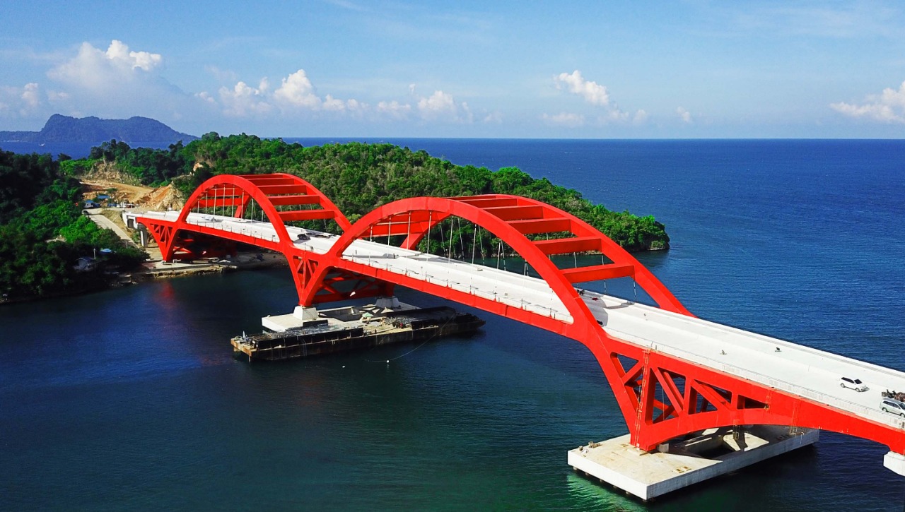
The Youtefa Bridge is difficult to miss when approaching Jayapura from the eastern side of the city. Its red steel arch stretches across Youtefa Bay, forming one of the most recognizable silhouettes in Papua.
Yet the bridge’s significance is not simply visual.
Since opening in 2019, the structure has changed the way people move between central Jayapura, Hamadi, and Muara Tami. A journey that once required a longer route around Youtefa Bay can now be completed much faster, bringing residential areas, agricultural producers, businesses, tourism destinations, and the Indonesia-Papua New Guinea border closer to the city’s main economic center.
The bridge was officially inaugurated on October 28, 2019, by President Joko Widodo, following several years of construction. The project was developed as part of a broader effort to improve infrastructure in eastern Indonesia and strengthen connectivity in Jayapura.
For Papua, the project represented an important change in the relationship between infrastructure and development.
A road can connect two places on a map. A major bridge can change how those places interact economically.
That is increasingly visible around Youtefa Bay.
From Holtekamp to Youtefa
The bridge was initially known as the Holtekamp Bridge, after the area it connected.
Its name was later changed to Youtefa following a request from members of the local customary communities, including the Tobati and Enggros communities, because the bridge crosses Youtefa Bay. The new name consequently reflects the geography and local identity of the area.
That change is an important part of the bridge’s story.
Infrastructure is often described through engineering figures, construction budgets, and technical specifications. But major projects also become part of the social landscape in which they are built.
In Jayapura, the Youtefa name connects the structure to the bay and the communities that have long lived around it.
The bridge itself is approximately 732 meters long and 21 meters wide, with a steel arch design. It was among the most significant bridge structures constructed in Papua at the time.
The Indonesian government invested substantial resources in the project. According to available project records, construction involved a consortium led by PT Pembangunan Perumahan with PT Hutama Karya and PT Nindya Karya, while the main steel structure was manufactured by PT PAL Indonesia in Surabaya.
The project’s financing included approximately Rp1.3 trillion in central government funding, supplemented by contributions from the provincial and municipal governments.
An Engineering Story Across the Archipelago
One of the most remarkable parts of the project happened far from Jayapura.
The main steel arch was assembled in Surabaya rather than directly at the bridge site. Once completed, the structure was transported by sea to Papua.
The main component weighed about 2,000 tonnes and was transported roughly 3,200 kilometers over 19 days before reaching Jayapura. Installation of the major sections was then completed at the bridge site.
The decision to manufacture and assemble the main structure away from the final location reflected the technical challenges of constructing a major bridge in Papua.
The approach also allowed specialized fabrication and welding work to take place in a controlled industrial environment.
The project subsequently received recognition from the Indonesian Museum of Records, including records associated with the transportation of a complete steel bridge structure over a long distance and the installation of a large complete steel frame.
For Papua, the story was more than an engineering achievement.
It demonstrated that large infrastructure projects could overcome the logistical difficulties created by the province’s geography.
A Shorter Road to Muara Tami
The most immediate benefit of the bridge is measured in minutes.
Before Youtefa Bridge was available, travel from the Jayapura government center toward Muara Tami required a route of approximately 35 kilometers, taking about an hour under normal conditions.
With the bridge and its connecting roads, the distance was reduced to around 12 kilometers, with travel time falling to roughly 15 minutes.
That difference matters in everyday life.
For workers, shorter journeys mean more predictable travel.
For businesses, faster transportation can reduce logistics costs.
For farmers, it can make it easier to move agricultural products toward urban markets.
For residents, access to schools, healthcare facilities, and government services can become more convenient.
And for tourists, the bridge creates a more direct route toward destinations in eastern Jayapura.
Infrastructure becomes economically meaningful when these small savings accumulate across thousands of daily journeys.
Connecting Jayapura With Papua’s Eastern Frontier
The bridge’s strategic importance extends beyond Muara Tami.
It also improves access toward Skouw, Indonesia’s land border area with Papua New Guinea.
Available government and reference data indicate that travel from Jayapura toward Skouw, which previously could take around 1.5 to 2 hours, can be reduced to approximately 30 to 40 minutes using the Youtefa route.
That makes the bridge relevant to more than local commuting.
Jayapura occupies an important position in eastern Indonesia because of its proximity to Papua New Guinea and its role as the provincial capital.
Better connectivity between the city and the border area can support the movement of people and goods while strengthening the relationship between urban markets and communities farther east.
The bridge therefore forms part of a wider transport network rather than functioning as an isolated structure.
Its value grows as roads, commercial areas, agricultural zones, and border facilities around it develop.
A New Route for Agricultural Products
One of the clearest economic opportunities created by the bridge lies in Muara Tami’s agricultural areas.
The district includes productive agricultural areas such as Koya Tengah, which produces rice, corn, peanuts, sweet potatoes, vegetables, fruit, and poultry products.
Before the bridge, producers and distributors traveling between these areas and central Jayapura faced longer routes around Youtefa Bay.
The new connection provides a more direct route.
That can reduce transportation time and potentially lower distribution costs.
For perishable products, time is especially important.
Vegetables, fruit, poultry, and other agricultural goods can lose value when transportation takes too long or becomes unreliable.
A shorter route can therefore improve the connection between rural production and urban consumption.
The benefit does not necessarily appear as one dramatic change.
Instead, it can emerge through hundreds of smaller transactions every day.
Farmers get their products to markets faster. Traders spend less time on the road. Consumers gain easier access to locally produced goods.
Over time, those improvements can contribute to a stronger regional economy.
From Infrastructure to New Businesses
The bridge has also changed the landscape around its approaches.
Research examining the economic impact of Youtefa Bridge has identified the emergence of businesses around the surrounding tourism and transport corridors, including restaurants, cafés, shops, hotels, kiosks, workshops, and small fuel businesses. The study also noted the growth of tourism-related activity around Holtekamp Beach.
This is a familiar pattern in infrastructure development.
When transportation improves, locations that were previously less accessible can become commercially attractive.
People traveling across the bridge create demand.
A café needs customers. A roadside shop needs passing traffic. A tourism operator needs visitors. A small workshop benefits from a steady flow of vehicles.
The bridge can therefore create an economic multiplier effect.
The infrastructure itself does not automatically create successful businesses. Entrepreneurship, investment, local planning, and consumer demand remain essential.
But connectivity can create the conditions under which those activities become more viable.
Tourism Finds a New Landmark
The economic role of Youtefa Bridge is closely connected to tourism.
The structure has become a visual landmark in Jayapura, particularly because of its distinctive red arch and its position above the waters of Youtefa Bay.
From the bridge, visitors can see the surrounding bay and landscape.
That combination of engineering and scenery has made the bridge a destination in its own right.
The bridge also improves access to other attractions around Jayapura and Muara Tami.
For tourism planners, this creates an opportunity to develop a connected tourism corridor rather than treating individual destinations separately.
A visitor might see the bridge, continue toward Holtekamp, explore nearby beaches, visit local businesses, and then travel toward the Skouw border area.
Such routes can encourage visitors to stay longer and spend more locally.
That matters for small businesses whose income depends on tourism.
A Bridge Built Into Papua’s Development Strategy
The Youtefa project also needs to be understood in the context of Indonesia’s broader infrastructure strategy for Papua.
For many years, the central government and regional administrations have emphasized the importance of improving connectivity as part of Papua’s development.
The Youtefa Bridge was presented by Indonesian officials as an important infrastructure project for eastern Indonesia. The Ministry of Administrative and Bureaucratic Reform described the Holtekamp project as evidence of the government’s infrastructure commitment in the eastern part of the country.
This is particularly relevant to the framework of Papua’s special autonomy.
Special autonomy is not limited to fiscal arrangements or administrative authority. Its broader development context includes efforts to improve welfare, public services, and economic opportunity for communities in Papua.
Infrastructure is one of the tools through which those objectives can be pursued.
A bridge cannot solve every development challenge.
But it can remove one significant barrier: distance.
When distance becomes shorter, opportunities become more accessible.
The Social Meaning of Better Connectivity
The impact of a major transport project can be difficult to capture in economic statistics alone.
A shorter journey can change how families plan their day.
A student can spend less time traveling.
A patient can reach medical services more easily.
A farmer can access a larger market.
A worker can commute more efficiently.
A small business can receive supplies more reliably.
These are ordinary changes, but together they shape the quality of daily life.
That is why transport infrastructure often has an indirect social impact.
The bridge does not provide healthcare or education itself. It makes access to those services easier.
The same applies to economic opportunities.
The bridge does not create a business automatically. It reduces one of the barriers that businesses face when moving people, goods, and services.
Youtefa as a Symbol of Connectivity
There is also a symbolic dimension to the bridge.
The red arch has become part of Jayapura’s visual identity.
It appears in photographs, tourism material, and images of the city, turning infrastructure into a recognizable landmark.
Parkside Hotels describes the structure as a symbol of pride, progress, and hope for Papua, while also emphasizing its role in improving connectivity and creating economic opportunities.
The symbolism is reinforced by the bridge’s history.
Its construction required cooperation between central and regional government institutions, Indonesian state-owned companies, and local communities.
Its name reflects local customary input.
Its steel structure was manufactured thousands of kilometers away and transported by sea to Papua.
And its daily function is now tied to the movement of ordinary residents.
In that sense, the bridge represents both national infrastructure investment and local identity.
What the Bridge Means for Papua’s Future
The story of Youtefa Bridge is ultimately a story about what happens after infrastructure is completed.
The most important question is not whether a bridge looks impressive.
It is whether communities can use it to improve their lives.
The evidence from Jayapura suggests that the structure has already changed travel patterns and contributed to economic activity around its approaches.
The next challenge is to ensure that surrounding development remains sustainable.
Tourism growth needs appropriate environmental management.
Commercial development needs orderly planning.
Increased traffic requires maintenance.
Agricultural producers need reliable roads beyond the bridge itself.
Small businesses need access to finance, skills, and markets.
The bridge provides the connection. Other policies must make use of it.
A Long-Term Investment in Connectivity
As Papua continues to develop, the importance of connectivity is likely to increase.
The province’s geography means that transportation costs and travel times can influence everything from food prices to access to public services.
Large infrastructure projects can therefore have effects that extend well beyond their immediate location.
Youtefa Bridge offers a useful example.
A single connection across Youtefa Bay has linked Jayapura more closely with Muara Tami and the eastern border corridor.
It has also created a tourism landmark and supported new commercial activity.
That combination is precisely why infrastructure remains an important element of regional development.
Conclusion
The Youtefa Bridge has become one of Jayapura’s defining landmarks, but its importance goes far beyond its striking red steel arch.
Completed after several years of construction and officially inaugurated on October 28, 2019, the bridge was designed to improve connectivity between Jayapura, Hamadi, and Muara Tami.
Its impact can be seen most clearly in travel times.
The journey from central Jayapura toward Muara Tami was reduced from approximately 35 kilometers and one hour to around 12 kilometers and 15 minutes. The route toward the Skouw border with Papua New Guinea also became significantly faster.
Those changes have economic consequences.
Agricultural products from areas such as Koya can reach Jayapura more efficiently. Tourism destinations become easier to access. New businesses can develop along the corridor. Residents can spend less time traveling between different parts of the city and its eastern districts.
The bridge also carries a cultural dimension through its Youtefa name, chosen following local customary input and reflecting the bay over which it stands.
Its broader significance lies in what connectivity makes possible.
For Papua, infrastructure development is most meaningful when it translates into better access, lower transportation barriers, stronger local economies, and greater opportunities for communities.
Youtefa Bridge does not represent the end of that process.
It is a piece of infrastructure that enables the next stage.
As Jayapura and the surrounding areas continue to grow, the red bridge across Youtefa Bay stands as a reminder that development is often measured not only in concrete and steel but also in the distance people no longer have to travel to reach opportunity.