
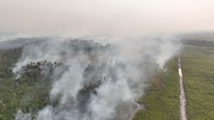
When the first signs of widespread forest and land fires appeared across Papua Barat (West Papua) Province in late August, the scale of the problem quickly became visible from satellite monitoring. On August 25, 2026, authorities recorded 399 hotspots across the province. Two days later, that number had fallen to 68, a sharp decline that reflects intensified monitoring, field response, and coordination among government agencies and security personnel.
The reduction is significant, but Indonesian authorities are not treating it as the end of the crisis. The Meteorology, Climatology, and Geophysics Agency (BMKG) has warned that the current dry season is being intensified by El Niño, creating conditions in which new fires can emerge even after existing hotspots decline.
For Papua Barat, the challenge is therefore becoming a test of whether emergency action can be converted into sustained prevention. The provincial government has established a joint task force involving multiple institutions, while local authorities are urging communities to avoid opening or expanding agricultural land through burning.
Hotspots Drop by More Than 80 Percent
The latest satellite-based figures show how quickly conditions changed over three consecutive days.
On August 25, BMKG detected 399 hotspots in Papua Barat. Fourteen were classified as low intensity, 348 as medium intensity, and 37 as high intensity.
By August 26, the number had fallen to 224 hotspots, comprising 13 low-intensity, 203 medium-intensity, and eight high-intensity points.
The decline accelerated on August 27. BMKG detected only 68 hotspots, consisting of 58 medium-intensity and 10 high-intensity points.
That represents an overall decline of about 83 percent in two days, from 399 to 68 detected hotspots.
The figures offer an encouraging sign for communities facing the consequences of smoke and fire. Yet BMKG climate analyst Wendel Jan stressed that a decline in hotspots should not automatically be interpreted as a decline in the overall risk of forest and land fires.
That distinction is important. A hotspot detected by satellite is an indicator of thermal activity, not necessarily a direct measurement of the total area burning. Weather conditions, cloud cover, vegetation, and the duration of a fire can also influence detection.
In other words, fewer hotspots mean that the immediate picture has improved, but they do not guarantee that the threat has disappeared.
El Niño Raises the Pressure
The environmental challenge facing Papua Barat is being amplified by prolonged dry conditions.
According to BMKG, the entire province is experiencing rainfall deficits, with Fakfak and Manokwari Selatan among the areas particularly affected. In some locations, the number of consecutive days without rain has reached around 55 days.
The situation is particularly serious in Fakfak, where many of the remaining hotspots have been detected in Bomberay District.
BMKG has also warned that the El Niño phenomenon is currently in the strong to severe category. Its peak is expected around September and October 2026, with effects potentially continuing into early 2027.
That forecast gives the recent decline a different meaning. The government has succeeded in bringing down the number of detected hotspots, but the climatic conditions that allow fires to spread remain in place.
For communities living close to forests and agricultural areas, the situation means that prevention may be just as important as firefighting.
Papua Barat Builds a Joint Response
The provincial government’s response has increasingly focused on coordination rather than relying on individual agencies.
On August 24, the Papua Barat provincial government announced the establishment of a task force to strengthen its response to forest and land fires. The task force brings together government institutions as well as the Indonesian military and police.
The provincial government says the task force will not only respond to fires after they occur. It is also expected to conduct regular monitoring and improve early detection of potential fire locations.
Plh. Secretary of the Papua Barat Provincial Government Abdulatif Suaeri said the task force would formulate an integrated response, including establishing a command post to monitor developments on the ground. The government also intends to maximize information systems and satellite hotspot data to strengthen monitoring.
This approach matters in a province where geography can make emergency response difficult. Some fire locations are remote and inaccessible to conventional firefighting vehicles.
The provincial government has, therefore, requested support from the National Disaster Management Agency, or BNPB, for one water-bombing aircraft. The equipment is intended for areas that are difficult to access by land, including Babo District in Fakfak Regency.
The move illustrates the logistical reality of managing environmental emergencies in Papua. The province’s forests, mountains, and dispersed settlements make rapid intervention more complicated than in densely populated regions.
Preventing Fires Starts Before the Flames
Firefighting alone cannot provide a long-term solution.
Provincial officials have repeatedly urged residents not to clear or expand agricultural land by burning, particularly during the current dry conditions. The government’s task force is also expected to strengthen public education and awareness campaigns.
The message is straightforward: a practice that may appear manageable under normal weather conditions can become dangerous during prolonged drought.
When vegetation dries out, fire can spread faster and become more difficult to control. A small agricultural fire can potentially develop into a larger forest or land fire, threatening nearby communities and ecosystems.
This is why the current response combines several elements: satellite monitoring, local patrols, public education, firefighting resources, and coordination among provincial and district governments.
The strategy also places local communities at the center of prevention. Government agencies can monitor satellite images and deploy personnel, but residents are often the first people to see smoke or flames.
That makes community reporting and responsible land management important parts of the broader response.
Smoke Becomes a Public Health Concern
The consequences of forest and land fires are not limited to vegetation.
Smoke from recent fires has reached Manokwari, the provincial capital. Local residents reported seeing smoke in the city, while personnel from the Manokwari military district were involved in firefighting efforts in the Gunung Kapur area of Maripi Village.
The precise cause of the fire at Gunung Kapur had not been established at the time of the report, underscoring another challenge for authorities: not every fire can immediately be attributed to a particular activity or actor.
The Indonesian military has also provided additional support to local governments. According to Jubi, 28 firefighting vehicles supplied through the Ministry of Defense have been distributed across Papua Barat and Papua Barat Daya to assist regional authorities.
For residents, the arrival of firefighting equipment is practical rather than political. It can mean faster access to water and equipment when flames approach settlements, roads, or productive land.
At the same time, smoke exposure can affect daily activities, particularly for children, older people, and residents with respiratory sensitivities. This makes prevention important not only from an environmental perspective but also from a public welfare perspective.
A Wider Test of Environmental Governance
The Papua Barat situation also highlights a broader question about environmental governance in eastern Indonesia.
The province contains extensive forest landscapes and natural resources that are important to biodiversity, local livelihoods, and the regional economy. Protecting those resources requires more than responding to individual fires.
It requires consistent land management, reliable environmental monitoring, and clear coordination between provincial and district administrations.
The task force model announced by Papua Barat is designed to address part of that challenge. By bringing together civil authorities, security institutions, and technical agencies, the government is seeking to reduce gaps between detection and action.
This is particularly relevant because the current fire season is unfolding alongside a wider national effort to strengthen responses to forest and land fires. Indonesian authorities have also been investigating possible criminal activity associated with some fires elsewhere in the country, including alleged forest encroachment and other forestry offenses identified through hotspot monitoring.
For Papua Barat, however, the immediate priority remains practical: detect fires early, contain them quickly, and prevent avoidable new fires.
The Numbers Are Encouraging, but Vigilance Must Continue
The fall from 399 hotspots on August 25 to 68 on August 27 is a meaningful improvement. It demonstrates that rapid coordination and intervention can produce visible results in a short period.
But the decline should not create a false sense of security.
The remaining 68 hotspots include 10 classified as high intensity. More importantly, the climatic conditions remain unfavorable. BMKG expects El Niño to reach its peak around September and October, while rainfall deficits continue across Papua Barat.
That means the next phase of the government’s strategy may be even more important than the initial emergency response.
Authorities will need to maintain satellite monitoring, continue field patrols, ensure firefighting equipment remains available, and strengthen communication with communities. Public awareness will also have to remain active throughout the dry season rather than only when smoke becomes visible.
For the international audience following developments in Papua, the episode offers a useful illustration of how environmental risks intersect with governance, infrastructure, and community participation.
Looking Ahead
Papua Barat’s recent experience shows that environmental emergencies usually have multiple causes and complex solutions. Climate conditions can increase vulnerability, while human land management practices can determine whether that vulnerability becomes a major fire.
The provincial government’s response therefore needs to remain both immediate and preventive. Firefighting can suppress today’s flames, but sustainable land management and community awareness are what can reduce tomorrow’s risks.
Conclusion
Papua Barat has recorded a striking decline in detected hotspots, from 399 on August 25 to 68 on August 27, 2026. The improvement coincides with strengthened coordination by the provincial government, the establishment of a multi-agency task force, and expanded monitoring and firefighting support.
Yet the achievement should be viewed as an important step rather than a final victory. The strong El Niño phenomenon, prolonged rainfall deficit, and continuing dry season mean that fire risks could return quickly.
The most sustainable measure will be to combine government capacity with community responsibility. Better satellite monitoring, faster emergency response, stronger public education, and safer agricultural practices can help protect Papua Barat’s forests while reducing risks to communities.
In that sense, the recent decline in hotspots is more than a favorable statistic. It is an early indication that coordinated public action can make a difference. The real test will be whether that momentum can be maintained through the months ahead, when climate conditions are expected to remain challenging.

